Victoria > East Coast > Phillip Island
Dunvegan Road, Phillip Island
| Type | Coastal cliff |
| Conditions | SSW (214 deg true) |
| Height | 50ft |
| Rating | HG Int, PG4, PG3 under supervision of PG5 |


Landowners
Phillip Island Nature Park
Contact
Anthony (0421 600 870)Responsible
Skyhigh - Michael Narcarrow (0418 331 740)Description
Dunvegan road, Phillip Island is a 50 ft high cliff site offering pleasant soaring in SSW winds with height attainable of up to 300ft ASL in good winds.
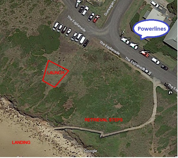
Set up is either in the car park at the end of Dunvegan Rd (if room) or on the grass just in front.
Takeoff
Take off is from in front of the car park. The recommended wind for hang gliders to take off is at least 13 to 14 knots from SSW, and from a position about 15-20 metres forward from the car park fence where the launch slopes down.
Paragliders choose the best strength for your wing and ability. Beach launching is possible in stronger winds - just choose the best location to do it from high tide line. Never climb in the dunes as this is an sensitive area.
Landing
Beach Landing Only. Strictly No Top Landing as per council’s requirements for permit.
There is generally no landing area on the beach at high tide but because of the gradual slope of the beach there is plenty of landing area once the tide is a little lower. Placing a wind indicator on the beach is recommended to determine the best landing direction.
There is a set of stairs just to the left of take off for you to carry your glider back up the hill. Avoid flying over roped off hooded plover nesting areas to the west during the nesting season and do not tramp on shearwater nests on the clifftop.
Beachgoers tend to occupy areas close to the access staircase. Please avoid landing close to beachgoers for convenience.
Flight
Due to migratory birds flying operations are only to be done between sunup and sundown.
The beat in a good wind extends to the east to Forest Caves. NOTE: Sightseeing helicopters from the Phillip Island airfield cross the coastline at the Colonnades fairly low on their way from and to island tours. It may be possible in exceptional winds to fly past there and onward toward the Cape along the dunes, however there is a substantial outcrop at Cape Kitchen that may present a hazard.
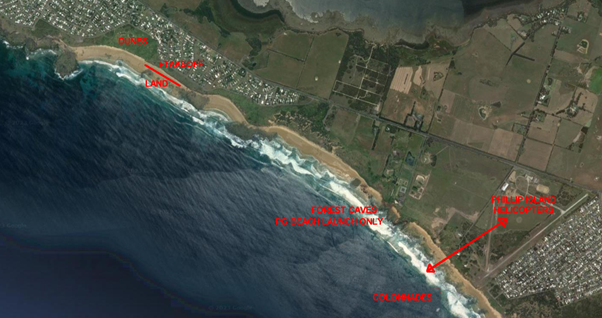
To the west the cliffs themselves drop away after 150m, cutting back to dunes with considerable shearwater nesting areas and possibly hooded plovers in season. 100m clearance should be kept from wildlife refuges. To the left of take off the beach has several exposed rocks and care should be taken not to get low in that area and be forced to land among them.
Pilots must be able to show a copy of the permit from the Phillip Island Nature Park on demand along with proof of SAFA membership to park rangers or council representatives. It can be downloaded from the Downloads page of the VHPA web site under the "Parks Victoria, DELWP and other land managers" header as "Phillip Island Site Permit".
Weather station: https://www.wunderground.com/dashboard/pws/ISURFB3
Hazards / Comments
The launch area is only big enough for one glider at a time. Please be courteous to other pilots and especially users of the adjacent car-park.
Caution is needed in strong winds due to…..
Building behind launch,
Car Park behind launch and public road
High voltage powerlines off to the left just over the road.