New South Wales > Hunter Valley
Glennies Ridge - Lake St Clair (Little Europe)
| Type | Inland ridge |
| Conditions | SW-NW |
| Height | 1950ft/596m asl |
| Rating | PG3 / HG Intermediate |


Landowners - ?
Contact/Responsible
NHGCDescription
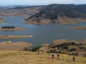
The NHGC administers, maintains and operates from a site from within the confines of the NSW Water Dept land at Lake Saint Clair in the Hunter valley. Lake St Clair is located 30Km north of Singleton along Bridgman Road. There are two access tracks from the road north and south of the ridge and both require a 4WD for access to the launch at 1,952 ft AMSL. The landing area is located on the other side (water side) of the road and slopes down toward the water. A wind indicating streamer is usually on the fence next to the access gate.
Pilots are reminded that this site resides within the Restricted Airspace R583B. When active the restricted area exists from the surface to 10,000 ft AMSL and flight above 300ft AGL is prohibited within the area. For further details and boundaries refer to the En-Route Supplement Australia or the Williamtown Visual Navigation Chart (VNC, can be viewed free online at Airservices Australia/publications/AIP). For advice on activation time(s) logon to the NAIPS service via the Air Services website. Login details and a procedure for accessing data on R583B is contained within the PDF Document "Procedure for R583B Status" on the NHGC Hunter Valley sites page..
All members who operate or intend to operate from this site are to make themselves familiar with the "Procedure for R583B Status" document and the "Glennies Ridge - Site Management Plan" available on the NHGC Hunter Valley sites page.
Site consent Conditions
Members of the NHGC and Visiting Pilots are required to abide by the following conditions whilst using the site. NSW Water reserves the right to withdraw site consent if the following is not adhered to:
- All Pilots using Glennies Launch site are to obey lawful directions of NSW water Staff;
- No modification, addition or removal of infrastructure is permitted without written approval from NSW Water;
- No modification to the environment is permitted with the exception of trimming of trees and other flora that would otherwise increase the safety risk to pilots when launching;
- All rubbish and litter that is brought into the site by members is to be removed when they leave the site premises;
- All pilots operating foot launched aircraft at the site are to be members of the Sports Aviation Federation of Australia (SAFA).
- All pilots operating foot launched aircraft at the site are to conduct their operations IAW CASA regulations, SAFA operations manual and the NHGC Pilots code of conduct.
Takeoff
The launch run consists of a cleared grassy slope facing west north west. The cleared grassy top of the ridge extends along the entire ridge length. Top landing is possible. Power lines run north/south along the ridge behind the fence to the east of launch and from the house and structures behind the ridge westward down the face of the ridge to the road and houses north of the bomb out field.
The access road to the launch is via a non maintained bush track which traverses the countryside across grassland and significant rocky areas. The track on several areas comes close to the drop of on one side and should not be attempted by low experience 4WD drivers.
Landing
Top landing or at the lakeshore, near Garrow Book Rd. The landing (bomb out) field for this launch site is surrounded on three sides by water formed from the lake and on the eastern side by the road and power line. There is a significant slope down to the water from the road. Tussock grass is an impediment to running when landing.
Map information
