Victoria > East Inland
Mt Dandenong
| Type | Inland mountain |
| Conditions | WNW |
| Height | 1460'/ 445m agl, 1935' / 590m amsl |
| Rating | Advanced HG. PG5 (with advanced inland experience and ground handling skills) |


Melway Ref 52 F11.
Landowners
Parks Victoria (Launch - included in the statewide licence agreement between Parks Victoria and the VHPA), Salvation Army (main LZ). You do not need to contact these property owners prior to or after flying. All issues should be communicated directly to the Melbourne Hang Gliding Club. Contact to these owners or the local site managers should only be made in emergencies when emergency access is required.
Contact
MHGC , PG evaluation contact: Airie Merlin (0474 128 219), PG evaluation contact: Clinton Arnall (0415 229 316), James Atkinson (0408 557 774), Ethan Glessich (0414 702 727)Responsible
Skyhigh , MHGC , Skyhigh - Michael Nancarrow (+61 418 331 740)See also
Takeoff
Take-off is a steep metal ramp (just above ground level) through a slot in the trees. There is limited clearance directly in front of the ramp. The width of the slot is not excessive and tall trees are predominant on both the southern & northern sides of the slot. Care must be taken in choosing the appropriate launch time & technique, so sufficient flying speed is available to clear the treed slot.
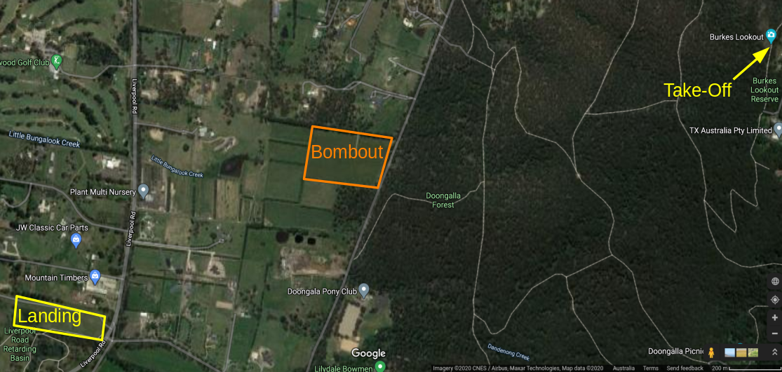
Landing
Landing paddocks are very limited, and it is critical that you contact the local club for the latest details.
The site’s landing paddock is the “Liverpool Road Retarding Basin” to the West of Liverpool Road. It is essential to check this prior to flying to familiarise yourself with the approach required.
The paddocks to the South of Pavitt Lane are owned by the Salvation Army can only be used in an Emergency, so you should not fly unless you are confident of reaching and landing in the Retarding Basin. If you do make an Emergency landing here, ensure you exit on foot to Pavitt Lane to the north. Do not drive into the paddocks or use Sheffield Road to access the paddocks from the south.
Please check these paddocks for stock and farm activity before driving to takeoff.
You must also avoid any low flying over the Buildings/Farm on Sheffield Road to the South of these paddocks. Failure to avoid this area will jeopardise the Emergency use of these paddocks.
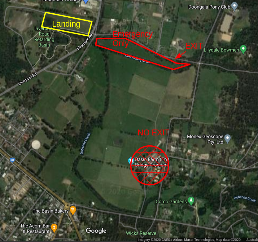
The main thing to remember on approach is to be very wary of horses in the area and not to spook them. This is an environmentally sensitive area, a lot of trouble and effort has gone into getting the Mountain as a flying site, and so we must be on our best behaviour at all times.
Flight
The site is sufficiently inland to produce good thermals in a variety of conditions from light and variable to moderate wind. In summer it is frequently flyable, however it comes under the influence of the sea breeze. In winter the take-off is often just above cloud base. It is a convenient site because of its closeness to Melbourne and its turn around time.
Hazards / Comments
Due to this sites closeness to Melbourne's main airport it is critical for pilots NOT to infringe on controlled airspace. Controlled airspace is at C LL 4500 over launch (only approx. 2000' above take-off) and drops to C LL 3500 in the suburbs out in front of launch. Pilots must carry altimeters and strictly observe these restrictions.
Guidelines
The club recommends that the site is only suitable to "Advanced" rated pilots, or suitably experienced "Intermediate" rated pilots with:
- Suitable Mountain XC experience.
- The judgment & skills to fly appropriately (read safely).
- Supervised (on-site) by an "Advanced" rated pilot with current local experience.
It is mandatory that pilots new to this site contact and fly with a pilot who is experienced in the site before flying it for the first time. (The club recommends Andy Phillips.) This site has specific no landing zones so check with one of the club's committee members or a regular local pilot for details.
Other notes
The site has limited (approved) landing zones which may not always have guaranteed glides to. For this reason it is only suitable to mountain XC experienced pilots, that have the judgement & skills to fly appropriately (read safely).
Map information
