Victoria > East Inland
Mt Donna Buang
| Type | Inland mountain range |
| Conditions | Light to moderate S or light N |
| Height | 3100' / 945m agl; 3540' / 1080m asl |
| Rating | Advanced HG only |


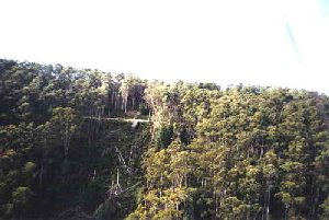
Overlooking Warburton. The ramp is on the Healesville - Mt Donna Buang Rd. approx. 1.5 km from the Summit Rd. leading up from Warburton. VicroadsV80 D5.
Landowners
Launch: Parks Victoria, this site is licenced to VHPA. Landing: Friendly if treated with respect, use below contacts for current protocol.
Contact
MHGC , Todd Wisewould (0407 754 938)Responsible
MHGCDescription
Ramp take off through a relatively long and narrow slot in tall trees. Faces south overlooking the Warburton Valley.
Closed during the ski season, Jun - Oct.
Takeoff
Drop gear off at the cleared setup area above the road and then park cars clear of the ramp being aware of parking restriction signs. Beware of traffic when carrying gliders across the road from the setup area and make sure not to block traffic. It is essential to begin launch at the apex of the ramp at the base bar chocks. Launching further back along the lesser incline is a practice which is absolutely unnecessary and only invites a nose high launch.
Landing
It is of PARAMOUNT IMPORTANCE that you are completely familiar with the properties we are allowed to land in. Failure to do so could place this site in jeopardy as there are properties we have been specifically asked NOT to land in. Please make sure you use the contacts below or make sure you talk to an experienced local pilot for these landing options prior to flying.
The previous LZ has changed ownership and was no longer suitable due to trees growing too tall around the perimeter. The new paddock is on Mc Namaras Rd in Milgrove next to the strawberry farm. There's a combination lock on the gate and a gravel track that takes you to the LZ which is the second last paddock before the Yarra River. It's a 5:1 glide from the launch and it's a big flat paddock with no obstructions. This is the closest decent paddock from launch. The owner of the LZ is ok with landings there as long as pilots contact the site contact Todd Wisewood first. Todd can give you the combination for the lock.
Flight
Ensure the wind is straight up the slot and then with a good launch technique there will be no problems. In thermal conditions or in wind directions other than a southerly it is essential to wait for a lull or a cycle to straighten the wind in the slot. This involves careful observation of the streamers and trees on either side of the slot making sure they are moving equally, otherwise strong rotor can be encountered.
This site can be flown in a number of wind directions giving a diverse range of flying conditions. In cooler Southerlies (10-15 mph) expect relatively smooth ridge soaring with occasional light cycles. Warmer days and light Southerlies can see more lively thermals but possibly the best conditions for thermal activity can be found in very light winds (0-5 mph) and light Northerlies (up to 10 mph) with healthy thermals triggering off the lee face. With the Northerlies some turbulence and associated sink has to be expected and unless in a thermal it doesn't pay to stay too close to the ridge but head straight to the logged area directly out front where a thermal can often be found.
Hazards / Comments
Controlled Airspace starts at 8500' asl above launch, with Jumbos flying directly down the range, check current VTC. Flying directly over the back will leave you with approx. 25 km of forest before the first landing.
Guidelines:
The club recommends that the site is only suitable to "Advanced" rated pilots, or suitably experienced "Intermediate" rated pilots with:
- Suitable Mountain XC experience.
- The judgment & skills to fly appropriately (read safely).
- Supervised (onsite) by an "Advanced" rated pilot with current local experience.
Map information
