Victoria > West Inland
Mt Hollowback
| Type | Inland hill |
| Conditions | S to WSW (West ok but avoid power lines), N (caution rotor) |
| Height | 300'/ 90m agl, 1800' / 545m asl |
| Rating | PG2 / HG Supervised |


From Melbourne, travel on the Western Highway. Turn north at the Midland Hwy outside of Ballarat. Nearest Town: Creswick. If the gate is locked, pick up the key from the house and LEAVE IT IN THE GATE (make sure you lock the gate properly). Later pilots can go straight in. The last person to leave returns the key. Vicroads Map 58 E9. Ballarat registered aerodrome is 5NM to the south of launch. CTAF 127.75
000 Emergency Markers (?)
- HOL100: North launch
Landowners
Launch access and North landing: Mr Norm Ross, Heyfield Park
Contact/Responsible
WVHGCDescription
 Change to the landing permissions to the South and South West face.
Mt Hollowback is a grassy, volcanic hill sticking out of the plains north of Ballarat. It has two microwave towers on the western 'peak' with a sealed road to the open take off areas. Popular with aero modellers and novice pilots.
Takeoff
North Face
Launch either from below the towers or at the base of the eastern hill for ground skimming flights. It is usually necessary to fly right, across the road to avoid landing in crops below the tower. This presents no difficulties and makes for good STU-NOVICE flights in good winds. Being of gentle slope, the north side is not worth a long trip for soaring pilots. Winds need to be about 18kts for even a meagre height gain and at that stage turbulence is noticeable. Thermals are often available but somewhat unusable given the high winds needed for ridge soaring.
South And South West Face
Launch is normally from south of the power line. A single-span power line runs down the northern end of the WSW face, being quite high off the ground at mid-span.
Landing
Landing to the north
The north landing paddock is large and clear but beware it slopes in places. Usually a very easy landing.
Landing to the south
Effective 28-Nov-2019, landing is not permitted in the lower paddocks immediately south of launch.
Pilots landing in these paddocks might be confronted by the landowners and asked to exit the property by walking their glider back up the hill. Pilots will need to avoid electric fences and be fit enough to make the steep climb back to the top.
The ground slopes towards the road.
There is a power line along the south of the road.
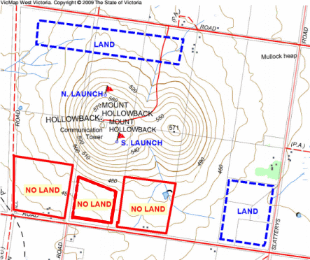
South landing options
The only bottom landing option is adjacent to Slatterys Rd. Here the ground slopes towards the road and there is a power line running along the south of the road.
Landing "West Paddock": Paddock to the West of launch with the dam can be used. Make sure you have enough height to cross the power line that goes from the lane to the tower. Walk your glider out of the gate & pack up in the lane.
There is a good area for top landing but give the towers a wide berth and keep cars back near towers to reduce hazards.
Flight
Good soaring available in more than 12 knots, airflow seems to be unaffected by hills in front even when blowing 20 knots. SW and SSE winds can produce areas of wave lift during evening glass-off. XC flights are made in 12 to 18 knots S to SW winds, clear the top by 500ft to avoid sink on lee.
Map information
