Queensland > South Queensland > Canungra
Mt. Tamborine
| Type | |
| Conditions | NW-SW |
| Height | 1798ft/548m ASL |
| Rating | PG4 , Hang gliding - Supervised. |


Landowners - ?
Contact/Responsible
CHGCSee also
Description
The site is only to be used by CHGC pilots or visiting pilots in the company of a CHGC member.
- PG2 rated pilots must have full SO supervision for the duration of their flight.
- PG2 rated Pilots are not permitted to fly between 10am and 3pm (1st September - 30th March) unless supervised by a CFI or SSO.
- PG3 rated pilots must consult with an SO prior to flying to ensure suitability of conditions.
Takeoff
Landing
Flight
CTA: 7500ft
Hazards / Comments
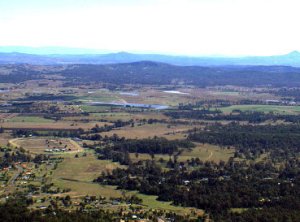
The first thing you'll notice when standing on Tamborine Launch is the amount of trees between you and the landing area.
The thing with Tamborine is there is little room for error, and it catches new pilots out EVERYTIME. No matter how much the Safety Officer emphasises on the following points, there is always one person that doesn't take it in. Don't be one of those pilots. Please read the following carefully, so that you don't end up in the trees and risk injuring yourself.
There can be very strong thermic cycles at Mt. Tamborine. Essentially what that means is that when air is going up very fast at Tambo, air very close to it is going down very quickly. A pilot will see another pilot going up in the near distance and head out, only to suddenly find themselves in extreme sink with little hope of making either the distant pilot or the landing area! Combine an unpredictable strong sink cycle with strong head wind and it will almost guarantee you end up in the trees, so the number one rule with Mount Tamborine is:
If you are not going up, head out to the landing field.
Now in case you're one of those people that skip over red bold writing, here it is again:
If you are not going up, head out to the landing field.
- If it is blowing from the north, it will almost certainly be rough air. Avoid flying in the northern bowl if it strong north otherwise you'll be flying in rotor.
- If it blowing strong from the south, judge your glider very carefully, otherwise you will not make the bombout. There is nothing but trees in between.
- Powered operations are prohibited at all CHGC launches.
- No acrobatics within a cylinder of 150m radius around any CHGC launch.
- First Aid box at the shelter in the main bombout.
- Spring and Summer see strong thermals with the possibility of major sink cycles
- Be aware of the wind strength and the distance to the bombout areas.
- Beware the level and degree of the sink cycles.
- Launch slope is shallower than ideal and is troubled by turbulence from the shelf in front of the launch and from the trees on the sides of the launch.
- Refrain from setting up landing approach low over houses near main bombout.
- The trees on the north side cause turbulence and wind shadow in a northerly wind.
- Beware of 7500ft height limit. (CTA)
- Because of the distance from the launch to the main landing site on Wagonwheel Rd all paraglider pilots need to fly in such a manner that a safe landing in the designated landing area is the primary flight plan if they are not gaining height. i.e. if the pilot is not gaining height, they need to be flying towards the landing area, not go scratching low hoping to find lift.
Map information
