Victoria > East Inland
Three Sisters (Flowerdale)
2024-03-25: Over the last few weeks ShyHigh have been working with the land owners of the Three Sisters flying site to resolve public liability insurance issues regarding flight activity at the site. Unfortunately the land owners advised they they are unable to obtain public liability insurance while flight activities are allowed at this site.
For this reason the Flowerdale - Three Sisters site is closed effective immediately.
Please be assured that SkyHigh will make all efforts to resolve the issue and have requested VHPA and SAFA assistance.
| Type | Inland hill |
| Conditions | Light to moderate N or S |
| Height | 750' / 230m agl, 1444' / 440m amsl |
| Rating | PG2 / HG Supervised (North), PG4 / HG Intermediate (South). |


Note that the site map deliberately does not show the exact site location - contact club member of MHGC or Skyhigh to locate.
000 Emergency Markers (?)
- SIS100: Launch
- SIS201: Landing - Paraglider landing
- SIS200: Landing - Hang glider landing
Landowners
This site is privately owned by Terry Hubbard. He doesn't need to be contacted when you arrive, but please be courteous and respectful when on the property.
Contact/Responsible
Skyhigh , MHGCDescription
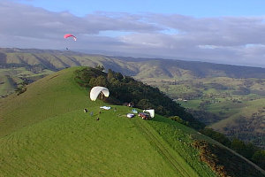
A smooth grassy double sided east / west ridge with both the north and south sides soarable and trees below the south launch. Automatic weather station here.
Due to rules put in place during negotiations with the Landowner this is a CLOSED CLUB SITE. You must be a current member, or accompanied guest of a member of the Melbourne Hang Gliding Club or Skyhigh Paragliding Club to fly this site, see below for contact details. Also, you must not fly alone - there must be at least two people, even non-flyers. The landowner prohibits dogs on the property. Pilots must not bring dogs or other pets on to the property. Smoking is prohibited anywhere on the property.
Takeoff
Launch is either side of the middle knoll. The northerly launch is completely open and the slightly rounded knoll allows a straight launch with slight amounts of NE to NW winds. The south launch with the close proximity of trees can be difficult due to the turbulence generated and is thus less forgiving.
Access to the top of the hill is STRICTLY 4WD ONLY, you must park 2WD cars near the bottom sign. Please keep the number of vehicles on the property to a minimum and strictly stick to tracks to avoid cutting up paddocks. Erosion, dust and other visible impact from too many vehicles running up and down the hill is much greater than the impact of flying overhead.
Drive slowly to minimise dust and noise - you are on private property. 20km/h absolute maximum on the gravel road into the lz and slower going past the two houses. Much slower when going past Terry's house on the the way up to launch (take the left hand track to the east of the house). The previous use of the track west of the house should no longer be used as it causes excess dust into the house. If you can see dust in your rear view mirror you're too fast.
At the landowner's request please do not ride in the back of utes or on vehicle roofs etc. It doesn't take long to make another trip.
No dogs allowed. Fox bait may be laid on the property.
Landing
North:
The paddock is large but slightly sloped away from the hill and as such your approach should be as low as comfortable into the paddock to give you plenty of room. Be aware of possible turbulence from other hills, especially in NW winds. In very light or nil conditions an uphill landing can be successful. There is a windsock on an orange PVC pole on the ground by the fence. Put it in the footing in the paddock, and the last person to leave can place it back by the fence and put the marker pole back in the hole. Terry (owner of flowerdale) has asked that the wind sock hole be made visible when not in use for safety reasons. The footing for the windsock is at co-ords S 37.29094 E 145.27245. Or, simply start at the green EMP pole located in the PG car parking area by the fence and walk 105m towards the notch in the hills on the horizon to the east.
South:
The landing area is along the Strath Creek Rd in one of the first three paddocks immediately over the creek. Check these paddocks before flying for stock or other obstacles and possible dangers (possible flooding in wet months).
Flight
This site is normally an easy site to fly to the north although can become quite turbulent in strengthening winds or if the wind swings. To the south you need to be careful on takeoff due to the turbulence produced by the trees in front of launch. Cross Country has potential, but works best when some initial height can be gained from ridge lift before having to work and possibly commit over the back in thermals. Flights from this site logged in Leonardo and the Paragliding Forum
Hazards / Comments
As mentioned above, All pilots must be current financial members of the Melbourne Hang Gliding Club or Skyhigh Paragliding Club. This site was only recently re-opened (February 1998) so please respect the site rules as arranged with the private owner of this property. In summer, drive very slowly along the dusty track from the highway to the LZ, because in a N wind, the dust blows onto the two or three houses along the way. There is a power line directly below the northern launch at the foot of the hill. There are also power lines in alternative landing paddocks on the south side. This site can become very turbulent in NE or NW winds, be extremely careful when low either side of knolls. This site is on the edge of a 4500' to 8500' controlled airspace step.
Map information
