Victoria > West Inland
Ben Nevis
| Type | Inland Mountain |
| Conditions | W, NW |
| Height | 1350' / 410m agl, 2400' / 730m amsl |
| Rating | PG4 / HG Intermediate |


There is a good though unsealed road running the entire length of the state Forest, from Raglan at the eastern end to Warrak in the west. Take the Mt Ben Nevis turnoff (well signposted) and continue on until the second left turn (Cowans trk). At the top of the next rise the track splits two ways. Take the right fork and continue 300 - 400m to the car park about 50m behind takeoff. Vicroads Map 57 E5.
000 Emergency Markers (?)
- BNS100: Launch
- BNS200: Landing - Bombout
- MTS200: Landing - Warrack long bombout
Landowners
Vic Govt, DSE (Dept Sustainability & Environment). This site is licensed to VHPA, refer DSE Licence on the VHPA downloads page.
Contact/Responsible
WVHGCDescription
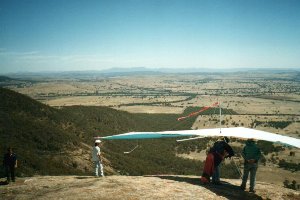
Large sheer mountain with clear takeoff and landing paddock below launch. IMPORTANT: Do not land in "No landing zone" South and East of Feud road. See area marked red on map below.
Your first flights here must be under supervision of a Western Vic club member to learn site protocols, prohibited landings and other land access restrictions. We have lost too many sites caused by unknowing visiting pilots and do not want to lose any more.
Visitors are welcome, but please contact us first. The club has annual running costs for this site's T/O & LZ and would appreciate regular visitors become a member of the club.
No flying from this site, or driving on tracks, during Total Fire Ban days. No vehicles in paddocks unless by the express consent of that owner. Keep speed low on dirt roads, especially near houses. No smoking on launch or landing zones. Pick up any rubbish you see, beside tracks, launch and landing areas.
Takeoff
Take off is a large granite outcrop, just below the summit and facing directly west. Although there is a sheer vertical drop of some 500' or more, the outcrop has a rounded edge at the top, minimising rotor and making good, clean takeoffs a fairly simple matter
Landing
The non cross country pilot or the unlucky will find room to land in front of take off on the north side of Feud Road. Do not land to the south or east of Feud Road. This was formerly a landing area, but landing there is now prohibited. See map. Alternatively, with only a thousand above, or thereabouts, the Warrak bomb out area is within reach. If landing at Warrak be sure to land well downwind of any trees and please avoid flying over the deer pens immediately west of the paddock behind the owners house.
Flight
The surrounding area possesses excellent thermal generating characteristics, with terrain ranging from tree covered earth to bare granite. Many thermals cook up on the flat ground out in front and are carried by the drift to the mountain. A good day will see the whole area providing lift. Ridge soaring is also possible in a moderate Westerly or North Westerly.
Cross country flights regular occur from this location. Almost every season now sees pilots flying in excess of 100km. Flights south to the coast and east to Ballarat are common.
Hazards / Comments
The main hazard is a power line servicing a lookout tower at the top of the mountain. It is a single line, supported only at the ends, running from top to bottom and is sufficiently far away from the mountainside to make hitting it a real possibility. Any pilot flying to the right of takeoff and below the top should know exactly where he is in relation to this line at all times. Orange marker balls are fitted but not that easy to see.
Map information
