New South Wales > Hunter Valley
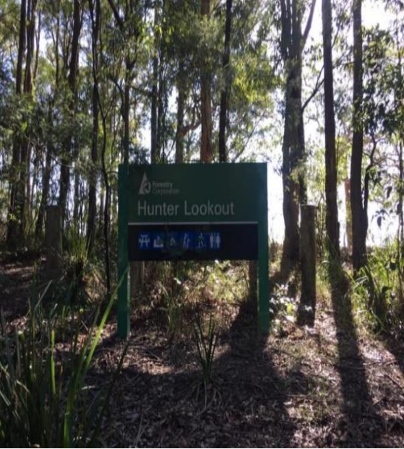
Hunter Lookout
| Type | |
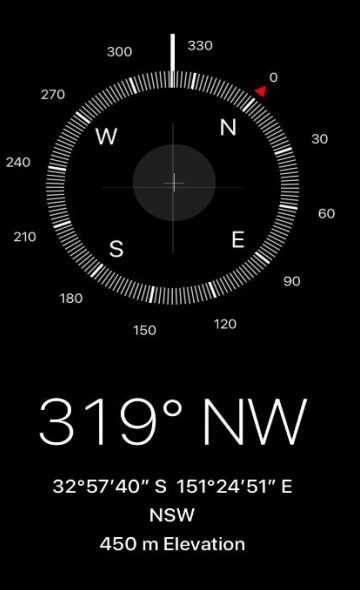
| Conditions | Launch faces NW at 319°, 8kn ideal |
| Height | 1476' or 450m |
| Rating | PG 5 • HG Intermediate |


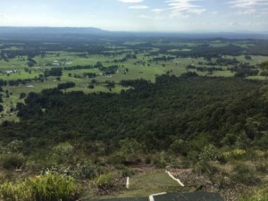
After arriving in Hunter Lookout, the car park, it’s a simple 2 min walk to the right of the viewing area down a small dirt track that is clearly defined to a few mats that have been placed by the Newcastle Hang Gliding Club and Newcastle Paragliding Club.
Landowners - ?
Contact/Responsible
NHGC , NPC Newcastle, NSWDescription
Airspace
- Class Q – Williamtown airport over launch Surface to 8500ft
- Class RMZ - Radio Mandatory Zone – Cessnock airport has Surface to unlimited once flying past landing areas.
- AirCheck | Australian Airspace & Flight Display (xcaustralia.org)
Weather Stations
Use Bom readings from Cessnock Airport for what will arrive 20 mins later at Hunters
General Tips and Information
- Winter flying here when the coast is not accessible due to NW winds
- When plenty of rain and grass is green, thermals will not be so active so the drier the area around the better thermals producing.
- Remember winter months the warmest part of day is between 2-4pm not 1-3pm like summer.
- A great idea is to go and walk the landing area and leave a piece of ribbon on a stick connected to the fence.
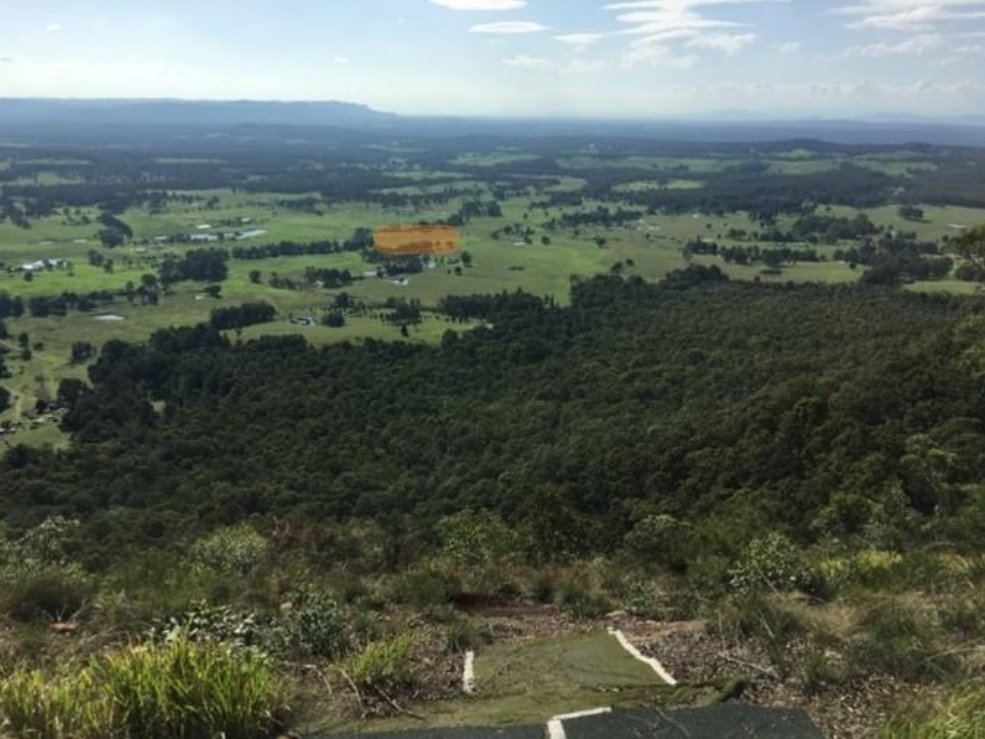
- To arrive at the landing area when you first arrive on Heaton Road look for Mill Lane crossroad and take it to Whiting’s Lane crossroad from the image above you can see the landing area. Drive down Whiting’s Lane towards the mountain range and roughly 600 metres on your right you will see the open field with a distinctive ladder over the fence.
- If heading to this site, it’s always a good idea to take a tree saw or cutters to prune back leaves and bushes so the glider does not snag.
- Longest XC distance from launch to Caves Beach (Hang glider) 27 Kilometres.
- Average phone reception in the area is 2 to 3 bars but not terrible.
Takeoff
- Take off has 5-6 artificial mats to lay out gear.
- Launch is very steep to a large drop off into some very large trees.
- Closest LZ is roughly 1.63 klms from the launch in a straight line before launching make sure it’s possible to make the LZ.
Landing
There is one landing zone, with a backup LZ in blue, much further away.
Damian LZ
- Damian’s LZ is roughly 1.63 Kilometres from the launch in a straight line, elevation of landing zone is 164 metres or 538 feet.
- Damian has given us access to his farm through his gate – please get the padlock code from one of the site contacts.
- Please lock all gates, cattle can be in paddock.
- If not parking at Damian’s, then cars need to be parked at the Crossroads 200M to the north on the dirt road.
See bottom of page for larger map of LZ’s in the area.
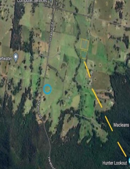
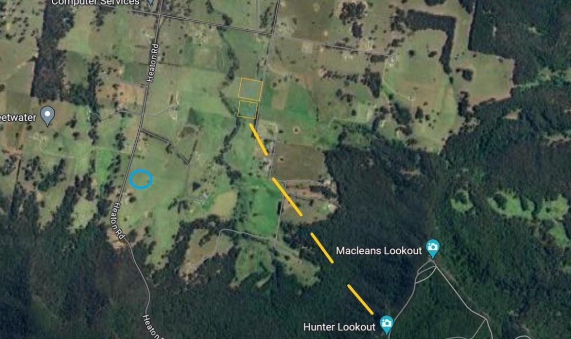
Damian’s LZ – Light Orange Backup LZ – Blue
Contact NPC or NHGC for contact telephone numbers.
Etiquette
OUR PRIVILIGE TO LAND AT LZ RELIES ON THE GOOD WILL OF LANDOWNERS
Damian’s Bomb Out
- Please only park at Damian’s Bomb out do not park on roadway.
- Ensure horse riding/training activities are not negatively impacted (communication is key).
- Damian’s Mobile: Numbers can be obtained by contacting NHGC or NPC members. If going to fly Hunters, please make your intentions known on the Fly Hunter (WhatsApp) group.
- Do not damage fences and leave gates as you find them, we only need one person to destroy something for the farmer to stop us from landing here.
- Please park retrieval car at crossroad of Mill Lane and Whiting’s Lane if not parking on Damian’s property.
Hazards / Comments
- Launch is very steep to a large drop off into some very large trees → great ground handling skills are required.
- Long glide to landing zones.
- Worst case is light winds 8 knots and below, insufficient to stay up ridge soaring but enough to make flying to the bomb out difficult.
- If wind is strong, you will be in a head wind to make the landing area
- If wind is too light you must head straight for landing area.
- This site has large trees and a long glide to landing making a tree landing very possible in bad conditions. Ensure to have spot-gps and some dental floss to enable rope to be raised or lowered if caught in a tree.
- EN B glider and above because of the long glide to landing zone and other farms in the area do not approve of landing anywhere else.
Map information
