Victoria > East Inland
Great Missenden (Previously known as Landscape)
| Type | Inland hill |
| Conditions | N-NE Launch |
| Height | 1400'/425m agl, 1804'/550m asl |
| Rating | HG Advanced / PG4, PG3 supervised by PG5 |


From Hume Mwy, turn to Ennis Rd at (-37.12967, 145.08926), follow Ennis/Main rd for 12km and turn to West Falls Rd. From Kind Parrot Ck Rd, turn to Fairview Rd at (-37.1736, 145.2550), follow Fairview/Main rd for 15 km and turn to West Falls Rd.
After the intersection with Freeman Rd at (-37.1257, 145.1785) , go through a closed gate with a code lock and follow a good track to an unlocked gate at the radio tower. Track from the radio tower to the launch is passable for a high-clearance 2WD in dry conditions, 4WD when wet. Driving to the launch in winter is discouraged (due to wet, soft track).
For the lock code, message your SAFA number to Neale Halsall at 0412 506 134.
No more than 10 cars to the launch private land from beyond the combination locked gate (minimize cars and carpool from LZ).
000 Emergency Markers (?)
- LAN100: Launch
Landowners
Private - As mentioned above the takeoff for this site is on PRIVATE PROPERTY and access is through a LOCKED GATE. The landowner does NOT want pilots to contact him, all information and correspondence should be made through the responsible club.
Contact
Skyhigh , Simon Birch (0409 568 316), MHGCResponsible
Skyhigh , MHGCDescription
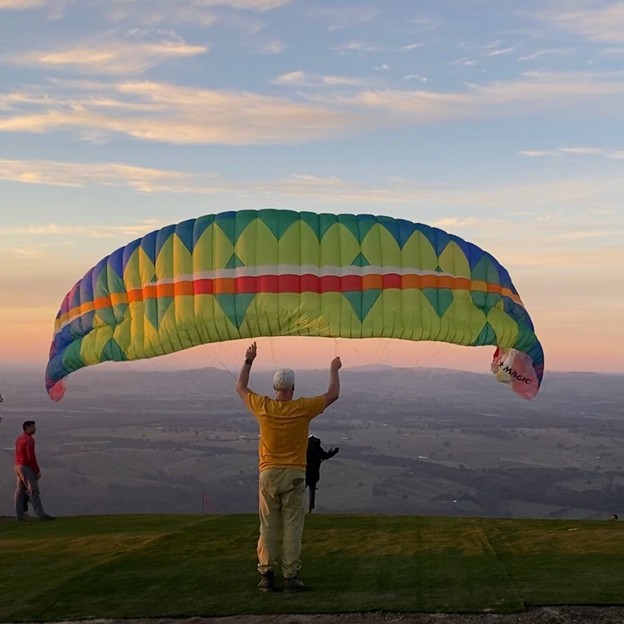
Paraglider and Hang Glider. NNE facing takeoff tree slot launch, wide enough for a single glider, new astroturf has been installed in May 2024 which gives a wider and cleaner launch area.
As per landowner agreement:
- Only use designated access path per description UNLESS emergency
- No dogs allowed
- SAFA members only
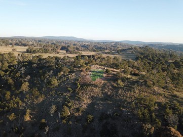
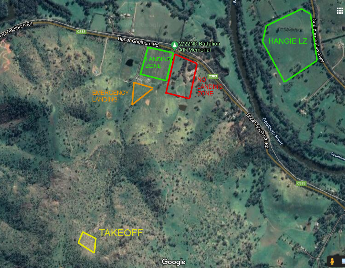
Takeoff
Ground ramp synthetic grass launch. 22m length x 12m width. Tree slot launch with some exposed rocks below the launch ramp.
Landing
Landowners - North LZ landowners are Simon & Nola Eden. They asked the visitors to notify Simon at 0409 661 230 before coming via SMS message.
It is possible to park on the landowners property: -37.08385, 145.17690
A maximum of 3 cars is recommended. Driving up the driveway and leaving cars next to the LZ gate. Please do not obstruct the driveway, gates, or park under the carport.
Even if it is possible to park on the property, we recommend that you park your car at the memorial (plenty of space and there is a toilet facility): https://maps.app.goo.gl/Gt63k7TH2GZ3uuYz7
The primary LZ is the paddock on the north side of the house, a large square paddock with a very slight decline in gradient (~3%). The hang glider bombout on the north of the river has changed ownership, the new owner will not allow his paddocks for landing.
The clear paddock on the south side of the house may be used as an emergency bomb out, however this land has a steeper decline in gradient.
Strictly no landing on the east side of the primary LZ. Separated by a small row of trees.
Top landings (possible but not recommended) possible in a paddock 200m south of the north launch. Also possible for paragliders to top land on launch (since May 2024 site upgrade).
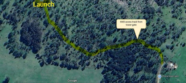
The hike up from the primary landing zone to launch roughly follows a vehicle track up the ridge with the single-wire powerline to the radio tower. There are different ways to reach the North launch, the easiest option (around one hour) is the one illustrated on the image below:
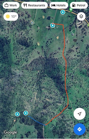
Instead of using the gate next to the house, please use the stile just at the corner of the property. See photo.
Flight
The following is strictly a guide, pilots must appreciate that turbulence increases exponentially as the wind strength increases. 18 knots is said to be the limit for hangies, less for PGs at about 10 knots. There will be a band of rotor to go through at about 130ft above, this should subside at about 80ft to 70ft, but be careful & ready. From the air you must assess the current conditions and choose the sweet spot. If uncertain, take the less convenient but conservative (SAFE) option and choose one of the bottom landing areas.
The club recommends that you have these skills / experience before flying this site:
- Suitable Mountain xc experience.
- The judgment & skills to read the conditions and fly if safe to do so
- Confident with forward launching in nil or cross wind
- First flight - Supervised (onsite) by an experienced pilot with current local experience.
Hazards / Comments
A single wire power line runs from the tower (to the east of the North launch) down the spur and across the river. It has marker balls on it but can still be difficult to see.
Stronger westerly direction of wind influence can cause turbulence at take off on the North launch. Consider this depending on the conditions on the day.
Katabatic wind has been witnessed regularly during the cold season close to the ground (from light to strong ESE wind) at the landing zone while Northerly at the top. Be aware of the turbulence (rotor) anywhere lower than 100 meters from the ground. Fog flow and dam wind ripples can be a good indicator of the wind direction in the lower layer. Wind turbines which are located North East of the launch can be an indication of higher level wind conditions.
AIRSPACE: If travelling south toward Melbourne, DO NOT infringe on controlled airspace. Controlled airspace is at C LL 8500 over launch and drops to C LL 4500 at Broadford less than 10km south.
Flying approx. 5km to the North you will approach Mangalore airport airspace, requiring you to carry and use a VHF radio (121.1 MHz) for a listen and broadcast.
Flying to the North-West you will approach Puckapunyal military base, which has a restricted airspace you are not allowed to enter.
Map information
