Victoria > East Inland
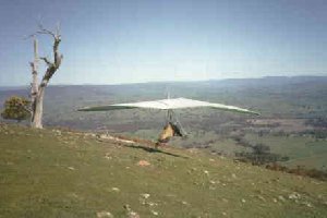
Mt Broughton (Thistle Hill)
January 2026 - due to recent bushfires, land managers have requested that we do not access the area until further notice.
| Type | Inland hills |
| Conditions | SW |
| Height | 2100'/630m asl 1400'/420m agl |
| Rating | PG2, HG Intermediate |


In the Switzerland Ranges, north of Yea. Vicroads map 61 E5. Take off is found by following Chisolm Rd off the Ghin Ghin Rd. Chisolm Rd is approx. 2km past Highlands.
000 Emergency Markers (?)
- THS100: Launch
- THS200: Landing - Hang gliders
- THS201: Landing - Paragliders
Landowners
The take-off owners (Alan and Dianne) are located in the building on the right-hand side of the road 1km from the take off area. PG & HG pilots to list their flying intentions as below. All this area is private land. Respect the cattle, give cattle plenty of space, there is a lot of paddocks available. Use gates and stiles where provided. Be considerate, show respect for the landowners and their property. You fly there only because of their blessing.
Contact
MHGC , HG - Neale Halsall (0412 506 134), PG - Jeremy Gough (0421 301 004)Responsible
MHGC , Skyhigh - Michael Narcarrow (0418 331 740)Description
Large grassy hill. A weather station is available. There is no SMS, phone or radio access to this weather station.
At the request of the landowners, no motorized flight (PPG/PHG) is permitted in the vicinity of this site. As a rule, do not conduct PPG/PHG flights near free flying sites unless you're certain that this will not endanger the goodwill which allows us to fly.
Takeoff
The take-off used to be covered with thistles (in the 1990's), hence the hangies called it Thistle Hill. There is a portable toilet on launch.
Landing
Paragliders
The PG landing paddock is located directly at the base of the hill. GPS: 55 H 0358715 UTM 5888504 Google Maps. Access to it is off Newell Rd via Switzerland Rd. Follow the laneway from 200m along Newells Rd where it turns right, directly toward the base of the hill. This is an easy glide for PGs providing they head towards the landing paddock once they descend to the tree-line, the best thermals are often found around the landing paddock itself! This site is suitable for novices but they are warned to avoid the strong thermic conditions that occur during the peak of the day in the summer.
There have been herds of nervous steers which get spooked by paragliders and even pilots walking through the paddocks. Land as far away from the cattle as possible, and avoid walking near them.
As at August-2025, the LZ property owner has requested the* following requirements* for use of the LZ:
- No landing on the property owner’s driveway.
- No landing near the property managers home or walking near the premises.- see landing/ no landing areas.
- Parking on Newells Road . (Vehicles are to be left 200m along Newells Rd where it turns right).
- You must post to the Inland Logistics Telegram Group, your intention to fly here.
- No Walking Access: Walking through the paddocks to the top of Mount Broughton is no longer permitted under any circumstances.
- If you wish to launch from the top, the only option is to arrange for a vehicle drop-off via another car.
- Walking on the property from your landing site back to your vehicle is permitted.
Register of Landings (Mandatory) Anyone wishing to land in the paddocks must provide the following details for each day via our Inland flying chat group (Subgroup: Register of landing at Mt Broughton). This is required to ensure safety and manage cattle in paddocks.
- Full name
- Vehicle registration
- Mobile phone number
Hang gliders
The landing paddock is located south of Switzerland road (See map).
There is an area on the north side in orange, sometimes some of the lower performance gliders can get caught short & land on the north side of the road. This paddock must remain an emergency landing.
The main landing used by paragliders can also be used if needed.
Please post to the Inland Logistics Telegram Group your intention to fly here.
Conditions of use
- All Gates are left ‘as found’.
- There is no smoking permitted at any time on the properties.
- No fires are to be lit on the properties.
- No litter is to be left on the properties.
- Visitors may not camp overnight.
- Flying operations shall only be conducted by current SAFA members.
- No pilot vehicles can enter the LZ ( gate is locked ).
- Pilots are responsible for keeping the Site clean and will leave nothing behind at the cessation of operations for the day.
- No Walking Access - Walking through the paddocks to the top of Mount Broughton is no longer permitted under any circumstances.
- If you wish to launch from the top, the only option is to arrange for a vehicle drop-off via another car.
- Walking on the property from your landing site back to your vehicle is permitted.
Register of Landings (Mandatory) Anyone wishing to land in the paddocks must provide the following details for each day via our Inland flying chat group (Subgroup: Register of landing at Mt Broughton). This is required to ensure safety and manage cattle in paddocks.
- Full name
- Vehicle registration
- Mobile phone number
Flight
Ridge soarable in a moderate south westerly, thermals can be expected during the warmer months. Flights from here on XContest
Hazards / Comments
Turn around from the car park to launch is approximately half an hour by car.
Many single wire (SWER) powerlines are in this area, some with 3 wires radiating from a single pole.
Be careful scratching below the tree line off launch in a paraglider. Sink can be brutal and there is a risk of not making the landing.
Retrieve Note for landing east of launch if you bomb before Molesworth: Switzerland Rd ends at a locked gate about 1.5 km east from Newells Rd. So if you land on the north side of the river, and less than 4 km to the east, walk west, and the retrieve vehicle can continue east along Switzerland Rd to get you, and meet you at the locked gate. But if you are more than 4km east along the ridge, especially further down the east end of the ridge, walk east until you connect with Fullertons Rd, which starts at a farmhouse and heads east, and joins up to the Molesworth-Dropmore Rd. The retrieve vehicle can get there via Highlands Rd, or via Yea and Molesworth.
Map information
