Western Australia > Wheatbelt
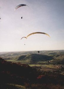
Mt Nardie, Toodyay
At the time of writing 1 May 2004 access to this site is closed. Contact Cloudbase Paragliding Club or the Hill Flyers Club to check on the current access arrangements. If you wish to contact the owner please go through the club.

| Type | Inland Ridge |
| Conditions | N-NE |
| Height | 700ft / 210m agl |
| Rating | PG: Intermediate with Site Induction; HG: Advanced (not recommended) |
The site is located in the Avon Valley near Toodyay, 1.5 hours drive east of Perth. There's gravel road access up a steep slope to the top. Some two wheel drives will have difficulty making it up even in the dry. No camping.
Landowners - ?
Contact/Responsible
HGAWADescription
A nice big hill, but oddly shaped. Excellent possibilities and views, but generally inconsistent flying, can produce excellent smooth evening flights when there's no wind elsewhere.
Takeoff
Very small takeoff. Towers behind and trees either side, you won't have more than a couple of feet between your wingtip and the trees at the back of the takeoff, but it opens out in front. Good ground handling required. Currently considered unsuitable for hangliders.
Landing
Same as Windmill Hill - powerlines powerlines powerlines. Apart from those it's also a longish glide and could be turbulent due to the railway, trees and hills in front in stronger winds. The obvious big field straight in front of launch is out of bounds at the moment, and also has a well concealed powerline across the middle. Land over to the right below windmill hill. Top landing is possible but not easy. The take off is quite small, but there are numerous areas of low scrub and blackboys on the top half of the hill offering landing possibilities for the adventurous. Warning - the scrub is taller than it looks, be prepared for some time spent untangling. Again, not a recommended option for hangliders.
Flight
This site is has a north south spur running out to the left of takeoff. If there is any west in the wind the spur will create rotor, and rough air in front of launch, although people have launched in slightly NNW conditions and glided across to windmill hill, it's not recommended. In the evenings the flat top of the spur can produce a surprising amount of lift, even extending out over the road on occasion. Stunning views and some cross country potential, although not a great ridge soaring hill due to it's convoluted shape and flattish slopes.
Records: PG: Open Distance 16km Mike Dufty, May 02; HG: ? About 200km a long time ago, was national record.
Hazards / Comments
As with all inland sites, this site has the potential to be treacherous. The site is at its best requires a north-north easterly wind. The most obvious hazard here is the powerlines, which surround the landing field. Landing area is the same as for Windmill Hill. Inspect the landing area from the ground before flying. Be sure you know where the powerlines are and plan a landing area before taking off. Do not fly this site unless you know you can land exactly where you want to. If you have enough height it is possible to fly over the powerlines and land near the dam. The landing area is a fairly long glide over trees and powerlines. Be sure to leave early enough and allow for possible sink. Don't fly here if you are unable to land in very confined areas amongst trees and rocks, this may be necessary if you encounter bad sink and can't make the landing field. The landing areas are not considered suitable for hang gliders.