Western Australia > Albany and South Coast
Porongorups
| Type | Inland Mountain Range |
| Conditions | N-NE, S(?) |
| Height | 500m+ |
| Rating | Not a rated site |


The Porongurup National Park is located half way between Albany and the Stirling Range National Park. Access via Porongurup Rd, well signposted from Albany Highway in Mount Barker at the west end and from Chester Pass Rd at the east end. Parking is located at Castle Rock carpark, and launch is accessed by a short but fairly steep hike along a firebreak/access track up the hill. Vehicle access has previously been allowed but unlikely to be granted due to difficult landowners at the base of the track.
Landowners
DBCA control the land that the Potato Farm launch is on, having resumed it into the national park some years ago.
Vehicle access may or may not be allowed, however it is through private property at the base of the hill. Ask the rangers when requesting the permit, as even they have to give notice if they need vehicle access.
Contact
DBCA - Albany ((08) 9842 4500), 120 Albany Highway ALBANY 6330, HGAWA , Albany Hang Gliding ClubResponsible
DBCA - Albany ((08) 9842 4500), 120 Albany Highway ALBANY 6330Description
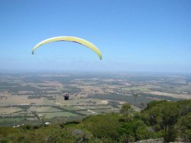
A small range of hills between the Stirlings and Albany, about 1800ft at highest point. Various launches have been flown from here in the past, however a permit is required to fly from the national park. Recent publicly announced flights have been from the old Potato Farm, but other launch spots may be available if the permit allows.
XC flights have previously been made south back to Albany and north to the Stirlings and beyond.
A permit required to fly from this site, obtainable from DBCA Albany Office given enough notice. The permit is single use and the rangers on-site must be notified the day before flying. Consult the permit application form for further reference.
Takeoff
A large unmaintained grassy area with a gentle slope on the northern face of the hill directly west of Castle Rock. Pick your lay-out spot carefully, as the grass can be shin-deep in places hiding rocks and holes. Small scrub and native ferns are regrowing so pick a clearer area to avoid snagging lines. DO NOT REMOVE ANY VEGETATION
There are tall kari trees around the perimeter of the clearing so expect some potential rotor from there.
Ensure your hillside landings are up to scratch as landing at the bottom of the clearing is much more preferable than not clearing the treeline and ending up suspended 20-30m from a tree. Even on a nil wind day you should have enough time for a turn or two to set up a landing before you reach the treeline.
Landing
As per the permit, landing is to be at the same place as launch, however this may not be practical on the day. Use your common sense, don't land on anyone's house and avoid bush bashing through the national park.
Flight
Not often flown due the permit requirement, but good views in all directions once above the hill, and even before that.
Be aware of rising winds in the afternoon as the sea breeze comes in from the south.
Local birdlife may not be used to us flying in their airspace and the national park is home to numerous Wedge Tailed Eagles who may become aggressive if they percieve a territorial intruder. Fly with caution.
Hazards / Comments
The national park area has many tall, dead treetops extending above the rest of the canopy, don't get low if you can help it. Maintain plenty of altitude for an exit glide at all times as the hillside ifself may not be within reach of the farmland at the edge of the park.
Many of the farmland paddocks on the nearby north side have vineyard wiring. Avoid landing here where possible. There's a couple of powerlines that run along the road and through paddocks in the farmland immediately south of the hills too, so double check your landing approach.
There are also numerous bluegum plantations in the area, ensure a decent glidepath over or around them as necessary.
The 10NM Albany Aerodrome airspace (YABA, CTAF 127.85) begins pretty much half way between the Porongurups and Albany (approximately Napier Hall if you're coming along Chester Pass Rd) so be sure to carry a VHF radio if going XC to the south towards town.