Australian Capital Territory - Canberra and NSW surrounds
Spring Hill

| Type | Inland Hill |
| Conditions | SW-NW |
| Height | 870m (2850') ASL, 200m (650') AGL |
| Rating | PG4 / HG Intermediate |


Landowners
Launch and landing are owned by Phil (a local HG and PG pilot).
Contact/Responsible
ACTHPASee also
Description
Spring Hill is the primary site for the Canberra region. It takes SW to NW winds. When the wind talker is in the range 16 - 28 km/hr you can easily soar the ridge. At other times it is often a thermal soaring site. If the wind talker is gusting greather than 25km/hr for supervised PG pilots or 40 km/hr for supervised HG pilots then conditions are likely too strong to fly.
Weather station: http://www.freeflightwx.com/acthpa/
Article: Flying Canberra
Please check ACTHPA guide for recent changes.
If it is your first time at the site, please find a duty pilot, safety officer or contact the club to have a site briefing prior to flying. The following link is some information you should be familiar with regarding the site: Spring Hill.pdf
This beautiful site is on private property. There is an honesty box located in a post on the right just after the dam. It is $10 a day for use of the site, or for a year's access you can leave $250 with Phil, or alternatively donate a day's labour assisting Phil on the property. Prior contact needs to be made with Phil Robinson on 0419 030 016 or Twitter: @SpringHillPhil before flying at Spring Hill. There is a QR code to scan at the front gate, which allows you to check-in so that the owner knows who is flying on the day. The gate must always be shut, because it it faces the highway. If you find it open, contact the owner to check if it has been deliberately left open.
Takeoff
Only 4x4 vehicles have permission to use the site, i.e. not wrx's and skylines etc, so please leave all other vehicle at the carpark in the LZ. It's a 25-30 minute walk to the top, or maybe you can carpool or catch a lift with someone driving up. Club protocol is to offer the driver $5 per lift up the hill to cover fuel and vehicle wear and tear. It is at the vehicle owner's discretion as to whether they accept payment.
The launch is accessible by a 4WD road that leads up the east spur of the ridge from the landing paddock. 
Landing
The primary landing is in the paddock to the right of the dirt road that leads up to launch. Do not set up for landing over or in the red marked areas marked on the map.
Flight
XC and ridge soaring flights are common.
Hazards / Comments
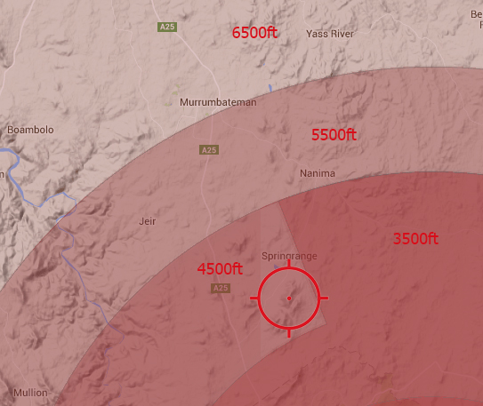
Airspace is quite low due to the close proximity of Canberra Airport. You can have a look at the different layers on AirCheck or just click on the image below to give you an idea of the airspace restrictions.
Map information
