Victoria > East Coast
Sunnyside
Since March 2016: Temporarily closed whilst development works take place on the golf course and other launch options are being considered.
| Type | Coastal Cliff |
| Conditions | NW |
| Height | 90'/ 27m asl |
| Rating | PG4 / HG Intermediate |


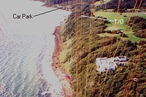
4km north of Mornington down the Nepean Highway. To get there take Sunnyside Rd, at the beach carpark drive in past the beach huts. It is a long climb up to cliffs to the left to the launches. Melways map 104 K6.
Landowners - ?
Contact
Jiri Stipek (0414 332 737)Responsible
MHGC , Skyhigh - Rohan West (0417 164 046)Description
Coastal cliff adjacent to the Mornington Golf Course
Takeoff
Two launches both cleared areas are located through the scrub at the top of the cliffs. A long, steep climb if you are carrying a hang glider.
Landing
The main landing area is the beach adjacent to the carpark. It is very short and very narrow. Suitable for paragliders or low performance hang gliders. Landings on top are STRICTLY PROHIBITED. DO NOT land in the golf course.
A much larger beach is located at Mornington, along the cliffs to the left, but watch out for signposts planted in the sand.
Flight
Once in the air, the main beat is around a kilometer long, however on a good day pilots can cross the carpark and fly down to Mount Eliza, total distance is around 8km. There are plenty of well shaped bowls along the ridge and good height can be obtained.
Hazards / Comments
Practically no landing area, strong wind gradients on certain days, and golfers complaining about pilots upsetting their tee-offs. Please do not fly directly above the mansions towards Mornington, many of the land owners get very irate.