Victoria > West Coast
Ocean Grove
| Type | Coastal Dunes |
| Conditions | S-SSW |
| Height | 45' / 15m asl |
| Rating | PG4 / PG3 supervised by PG4 / HG Intermediate |


From the Ocean Grove surf lifesaving club the takeoff is east on the old road directly below the Ocean Grove lookout. Melways Map 94 A6.
Landowners
Barwon Coast
Contact
Dynasoarers , Rob van der Klooster (0408 335 559)Responsible
DynasoarersDescription
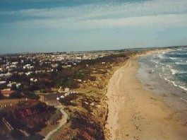
Coastal sand dunes from Collendina to Point Lonsdale. Height of dunes: 15 metres max. At some gaps, the front dune height drops to 2 metres.
Beach nesting birds: Hooded Plovers nest in this area. Visit this page to learn more.
Takeoff
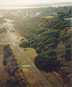
Access to launch is along the path passing below the lookout. See the picture for the location of launch.
Hang gliders can launch from the SE corner of the first car park or from the shared hang glider/paraglider launch just past the second carpark on the path. Paragliders shouldn't launch from the carpark upwind of any parked cars.
Please be mindful of persons using the pathway when setting up and launching.
Alternative launches exist at Pt Lonsdale (HG/PG) and Collendina (PG beach launch).
Landing
No top landings on the main launch area please (HG or PG).
It is a very quick walk up from the beach. Do not walk up the face of any dunes. There are steps back up to launch both east and west of launch.
The beach can be very narrow, or can disappear, when the tide is in.
A fence runs along the bottom of the dunes between the bluff and Collendina.
Please be mindful of any people on the beach when landing.
Flight
Note that the following minimum clearances are required during flight:
From persons –
- a minimum of 3 metres (unless the person is a pilot); and
- a flight direction, distance and height which avoids the risk of collision with persons.
From dwellings –
- (i) unless an occupier provides permission, a minimum of 10 metres horizontally and 100 feet vertically, noting pilots should minimise flights over dwellings); and
- a flight direction, distance, and height which avoids the risk of collision with persons and property;
- From the road – a flight direction, distance, and height which avoids the risk of collision with vehicles and persons.
Please respect the privacy of the residents during flight.
The Point Lonsdale Run is approximately 10km one way and you will rarely get over 100 feet. There is one very long gap, about 1km east of Collendina, and three or four smaller gaps on the way. There is an excellent view of "The Rip" at the Point Lonsdale end.
Pilots flying this trip should be HG intermediate/PG4 minimum and able to self launch. There are not many people on the beaches between launch and Point Lonsdale.
Hazards / Comments
There is turbulence when the wind is off to the right, especially if the wind is around 20 knots.